
So for this one, I am going to cover THE KERN RIVER. Please note the river is long and there are numerous paid/public campgrounds, paid/private campgrounds and free/dispersed campgrounds.
We go to a free/dispersed site (Lower Spring Hill Campground) but next to it is also Upper Spring Hill Campground which is a little rockier).
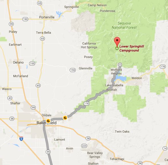
DIRECTIONS
I live in Orange County and going to the camp out at the Kern, I have to drive roughly 3 1/2 hours to get there which is about 190 miles. There are two main ways you can get there that is pretty easy. Notes the directions are from Anaheim, CA. I live close to Disneyland.
I-5 to CA-99 to 178/155/495 to HWY 99
1. Take I-5 NORTH to CA-99 then to CA-178 (E/Rosedale HWY) (roughly 136 miles)
2. You will take CA-178 to CA-155/495
(This is Wofford Heights Road that turns into Burlando Road then turns into Kernville Road) this will take you into KERNVILLE
3. It is a small stretch of road that ends on SIERRA HWY (which is also HWY 99). TURN LEFT
4. You will drive roughly 9 miles to get to Lower Spring Hill Campgrounds.
When you hit the 8 mile mark you will see CORRAL CREEK RESORT off to the right. They
have a daytime picnic area you if you are in to that kind of thing.
5. 1 mile past this is the entrance to both Lower and Upper Spring Hill Campgrounds. In the photo you will notice that it is marked only by a small sign. It DOES NOT have a Federal Park large brown sign. It's a small dirt path. You will see some port-a-potties by the entrance to the left of the path. We camp out by the trees on the riverbank directly across from the entrance. You can't see the port-a-potties in the photo since the trees are covering it.
6. The Road is NOT ask winding as the alternate way (listed below). It's more long and winding.
I-5 to CA-99 to CA-65 to CA-155 to HWY 99
1. Take I-5 NORTH to CA-99 then to CA-155
2. The road is SUPER INSANE WINDING up in the mountains. If you get car sick, this is NOT
the road you should take. But it is extremely scenic the closer you get to Wofford Heights.
3. The 155 will take you into KERNVILLE. Once you are in Kernville follow the directions above.

FIREWOOD - You CAN NOT BRING OUTSIDE WOOD TO THE CAMPGROUNDS. You can collect fallen firewood, but you CAN NOT chop any wood if it isn't already dead and on the ground. Of course, you can always make a small hop, skip and jump to BODFISH to go to the FIREWOOD GUY (https://www.yelp.com/biz/the-firewood-guy-bodfish). GUESS WHAT, they deliver to the campgrounds. Who knew!! They know the campgrounds like the backs of their hands. CALL first to make sure this hasn't changed.
-wheel barrow (soft wood) $20
-wheel barrow (hard wood) $25
-regular bundle (6.50)
ICE - You can always get ice at gas stations, Walmart, Sierra Market or Riverkern General Store to name a few. NO ONE in the Valley sells DRY ICE. Bummer!! We get ours at the closest Smart and Final (In Bakersfield - take I-5 to CA-99 but go up to the CA-178 turn left on "F" Street to it's end and the S&F is there). If your site is adjacent to the water, you can strap your ice chest to a tree with a rope. The ice will last several days this way.
FIRE PERMITS - You need a fire permit to use any of kind of fire at the campgrounds along the Kern River. Go to this site (http://www.preventwildfireca.org/Campfire-Permit/) and watch the 2 minute video. It will have a quiz section afterwards. Roughly 10 questions (if memory serves me correct). After the quiz it will provide you with a fire permit for you to print and keep with you at the campsite.
FIRE ALERTS - Check on the forestry page (https://www.fs.usda.gov/alerts/sequoia/alerts-notices) go to the middle of the page and you will see this section. Click on the KERN RIVER CAMPING RESTRICTIONS. See below the alert page to see the ORDER enforcing the fire regulations.
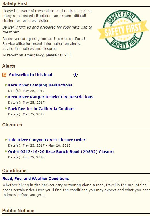

ROAD CLOSURES - http://roads.kerndsa.com/road-status-closures (map of all major roads) Here is a small snippet of the road closures. go to site and click the down arrow for more roads.
List is from May 2017.

BANKS - There are only 2 banks in Kernville. It is funny how one never thinks about this until
you are where you want to be and find you have to back track forever and a day to get back to it.
- 44 Big Blue Rd
Kernville, CA 93238 (760) 376-2251 - 27 Big Blue Rd
Kernville, CA 93238 (760) 376-2211


However, Lake Isabella has a few more.
- 5946 Lake Isabella Blvd
Lake Isabella, CA 93240 (760) 379-4671 - 5610 Lake Isabella Blvd
Lake Isabella, CA 93240 (760) 379-4335 - 6212 Lake Isabella Blvd
Lake Isabella, CA 93240 (760) 379-3642 - 6100 Lake Isabella Blvd
Lake Isabella, CA 93240 (760) 379-2691


However, Bakersfield has many more. I have listed the one for
Chase Bank. 2680 Mount Vernon Ave, Bakersfield, CA 93306 When you take the CA-99 to CA-178, it is there, close to a WALMART (2601 Fashion Plaza, Bakersfield, CA 93306)
FISHING LICENSE - BELOW are some of the places you can get a license.
Search Results


I saw no other animals other than squirrels. I saw some dragonflies, flies, birds, bees and ants.
Big ants that think you are a walking buffet of international flavor. What we do it bring but spray and make sure to sweep the ground where we are going to have our tent and then spray the bug stuff. Place down a tarp and put our tent on the tarp. Then we spray around the edges of that tarp. Our tent has a front porch area that is netted off, so we have it sprayed in there and we place a fake green grass carpet and a huge towel and a big tub of water to the side. So when we come in and rinse off our feet, dry with the towel and we can walk around our tent.
ELECTRICITY
None. Forget it. Unless your vehicle has an ac/dc port or a car battery port, your car or a generator is the only way you will be power up your electric stuff. One of the things I do is bring battery operated fairy lights. String those up in the tent or outside and it gives off enough light and can be turned off when needed. No plugs. Love Fairy lights.
VAULT BATHROOMS/SHOWERS - Only the paid/Public and paid/Private campgrounds have vault bathrooms. Some have showers. You can go to (http://www.kernvalley.com/news/kerncamp.htm) and it will list all the sites and how much it is per night, what basic amenities and what length RV's will fit. Please note that many of the paid/public do allow for RV's but some of the sites are small and some RV's will NOT fit.
RIVER ACCESS
As you can see you can choose from the Maps below you can choose from:
* LOWER KERN (South of Lake Isabella)
* UPPER KERN (North of Lake Isabella and Kernville)
* FORKS of the KERN (North of Johnsonville Bridge)
* THE PUT-IN- TAKE OUT map (4th one below) is where you can put your raft/kayak/tube in to float down and where you can take them out.
Lower and Upper Springhill is located almost dead center of the 3rd map. Right where it says Corral Creek. Between Salmon Creek Corridor and Thunder Run is a smooth 2+/- mile stretch of river perfect for tubing, even with small kids. Just make sure they are riding with an adult and are roped together.


INTERNET - For those of you who are tethered to the digital world, you lose internet connection even before you leave the Kernville city limits. Unless it has been boosted since last July 2016. So my suggestion for many of you is to try converting YouTube videos into files you access without internet access. If you have kids who are YouTube addicts (as my son is) You can go to the following website (https://www.onlinevideoconverter.com/video-converter). Go to You Tube, find your video and copy and paste the link into the converter. Make sure you choose MP4, MP4v or .mov or .avi and it will convert it so you can save it on your laptop or a removable drive once it has been completed. This is a total blessing since my son nearly melts down if he can't watch his videos. Weirdly enough they are how to videos.
TUBING/RAFTING
It has been quite some time since I have taken a vacation. Actually, last July 4th weekend was the last time. We went to the Kern River to go river rafting. It was between 90's to low 100's but there was enough of a breeze to make it enjoyable. Nights were just awesome. We have a portable fan that we did not need it. The lower end of the water is just the right depth to put your chair into the water and have the river rush over you. My little family LOVES this place.
There was this family that placed a rock wall going across the river about half way. They did this a decade or so ago and on the 4th of July weekend they were there again and reinforced the wall. This allowed the smaller children to play without the risk of them floating away in that split second where a parent might sneeze. If you type in Lower Springhill Campground KERN River, you will see some photos I posted online.
It is a dispersed site, so that means it's free, but it is first come first serve. No vault bathrooms, just several porta-potties. They clean them once a week and make sure there is enough toilet paper. I have yet to ever have NO toilet paper. I always carry my own on the off chance that it does happen. No showers. There are garbage dumpsters by the porta-potties. The good news is that the Rangers do come around to check out the crowds. On the 4th we had some serious jerks (to put it mildly) playing Narco-corridos till 3 am in the morning at full blast. They had a fire going (fire restriction) they had tubs of beer (glass bottles which are illegal there) and they were camped within 25 feet of the water. A huge Ranger who I dubbed the "walking tree trunk" came and had them leave. For the rest of us we were able to finally enjoy our week.
The cool thing about this river is there is a good 2 1/2 mile stretch of relatively calm water. You have a person drive up to the portion near Salmon Creek Corridor, drop off and then have the driver go back down to where Thunder Run begins which is a narrow pathway for the river to run through. Thunder Run is right where Lower Springhill ends. Just REPEAT!
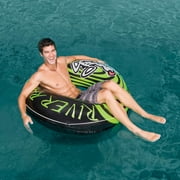
If you don't have any large inner tubes, just stop off at Walmart in Bakersfield to pick them up for under The red and white one is about $12.88 and the green and black is about $9.97. Sierra Market has similar, but I am unsure on the prices. I do believe they were a little higher, but not by much.

NATURAL ROCK SLIDES
If you go up HWY 99 further, you will pull off to the right to go towards the Peppermint Falls Campgrounds. These campgrounds are in the more forest portion (see 3rd photo below that someone else took, but it is a good shot of what it looks like there). So it feels more like you are enclosed with the beautiful tall trees around you. Very Cool.
But around this campground are natural water rock slides. (See photos below). There is a rope that someone strung up so you can climb back up the rocks once you've slide down into the water. The rocks can be wicked slippery. There is a small portion at the upper portion of the slides where you can place a chair and just chill under the shade with the comforting sounds of a tiny waterfall beside you. It doesn't look that high in the photos but the boys are 7 years old so a rope is needed. The algae makes it so slippery, I cannot express this enough. Wear something that will grip well. There is other rock slides, however those are usually more crowded and a little too extreme for kids. This one isn't crowded and is great for kids. The photos below were taken on Sunday July 3rd and it was vacant, until about 20 minutes in then another group with 7 boys showed up about the same age as my son. Serendipity! They all had such a blast.
Here is a video on HOW to get there, full directions. Click on this You Tube Link https://www.youtube.com/watch?v=8ukv9lUV3q4&t=109s
If you look at the Video it shows it much better.


To get to the waterslide: From the intersection of Western Divide Highway and Parker Pass Road (2.6 miles south of Trail of 100 Giants), head east on Parker Pass Road. After 6.5 miles, turn north on Lloyd Meadow Road (Forest Route 22S82) and take that road for 5.7 miles to a parking area on the right side of the road. A dirt fire road (Route 22S90) leads uphill to the left. Park where it is permitted and hike up the fire road up for half a mile. As the road rounds a bend, the creek will be visible pouring over a large rock. Break off the trail here and get ready for the most fun you can have in Giant Sequoia National Monument.
Trailhead address: Forest Route 22S82, Sequoia National Forest, Springville, CA 93208
Trailhead coordinates: 36.027466, -118.515284 (36° 01′ 38.87″N 118° 30′ 55.02″W)
Trailhead coordinates: 36.027466, -118.515284 (36° 01′ 38.87″N 118° 30′ 55.02″W)
Well, that is all I can think of now. I know i'll come back at a later time and revise this. Perhaps with lots more photos and videos. We shall see. 1 week and counting. Impatiently. Time to reset my internal clock. Whenever I camp, my whole body resets and I feel amazing. I also lose about 15 pounds do to all the hiking, swimming and tubing we do. BRING IT!!


No comments:
Post a Comment